Edition 1.0 · 2026 · Two sheets · 24 × 36 inches
The United States of America
Insular Areas and States. A map of the United States centered on its territories, compiled in Christiansted, U.S. Virgin Islands.

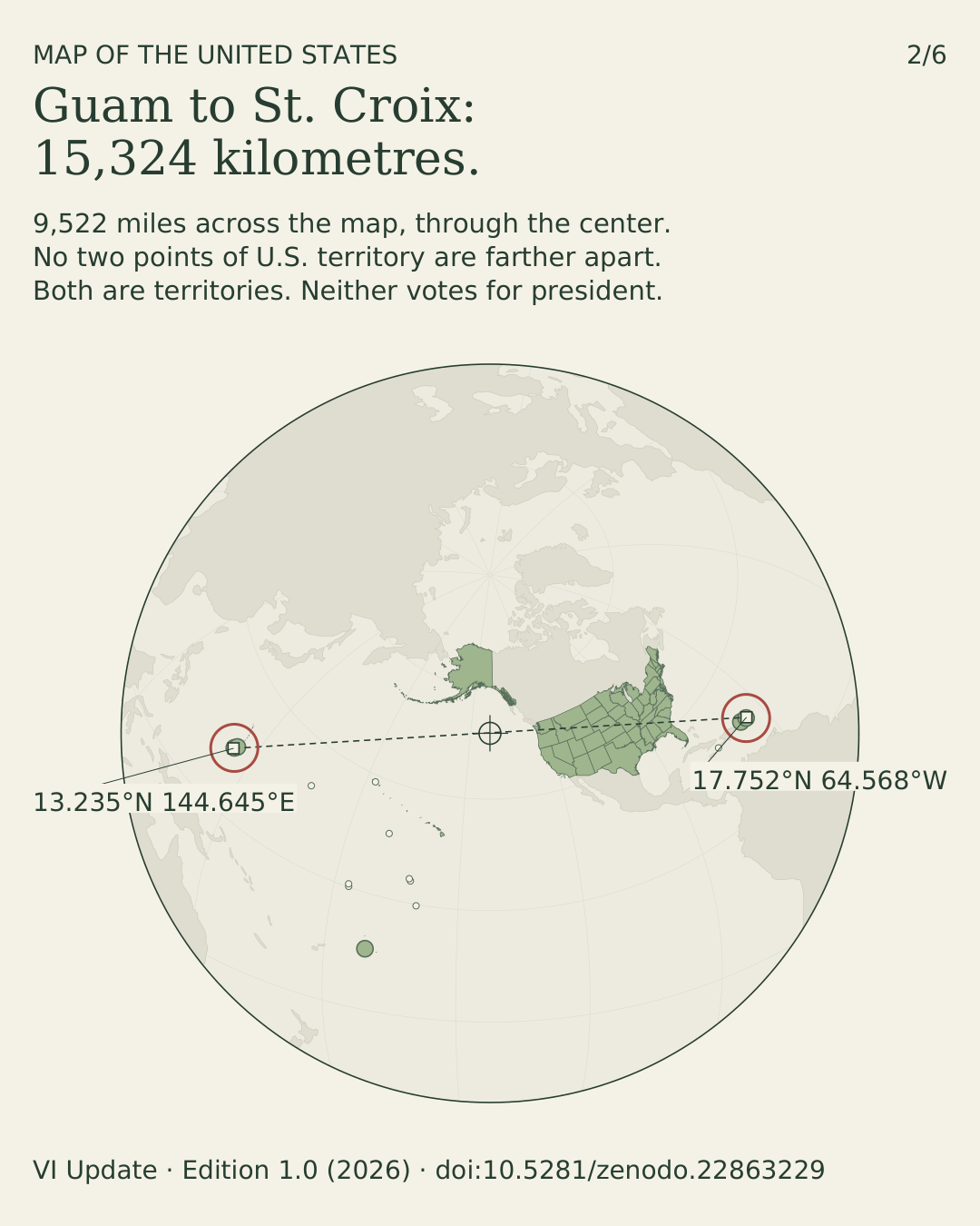
- 15,324 km
- Guam to St. Croix — the two most distant points of U.S. territory
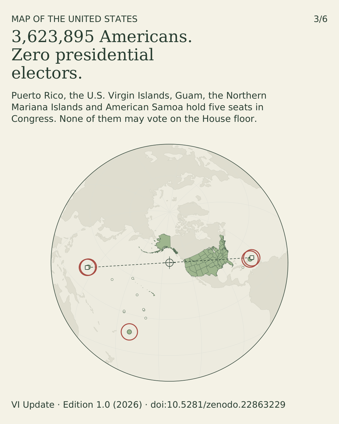
- 3,623,895
- Americans in the territories; no presidential electors, no floor vote in Congress
- 1 of 14
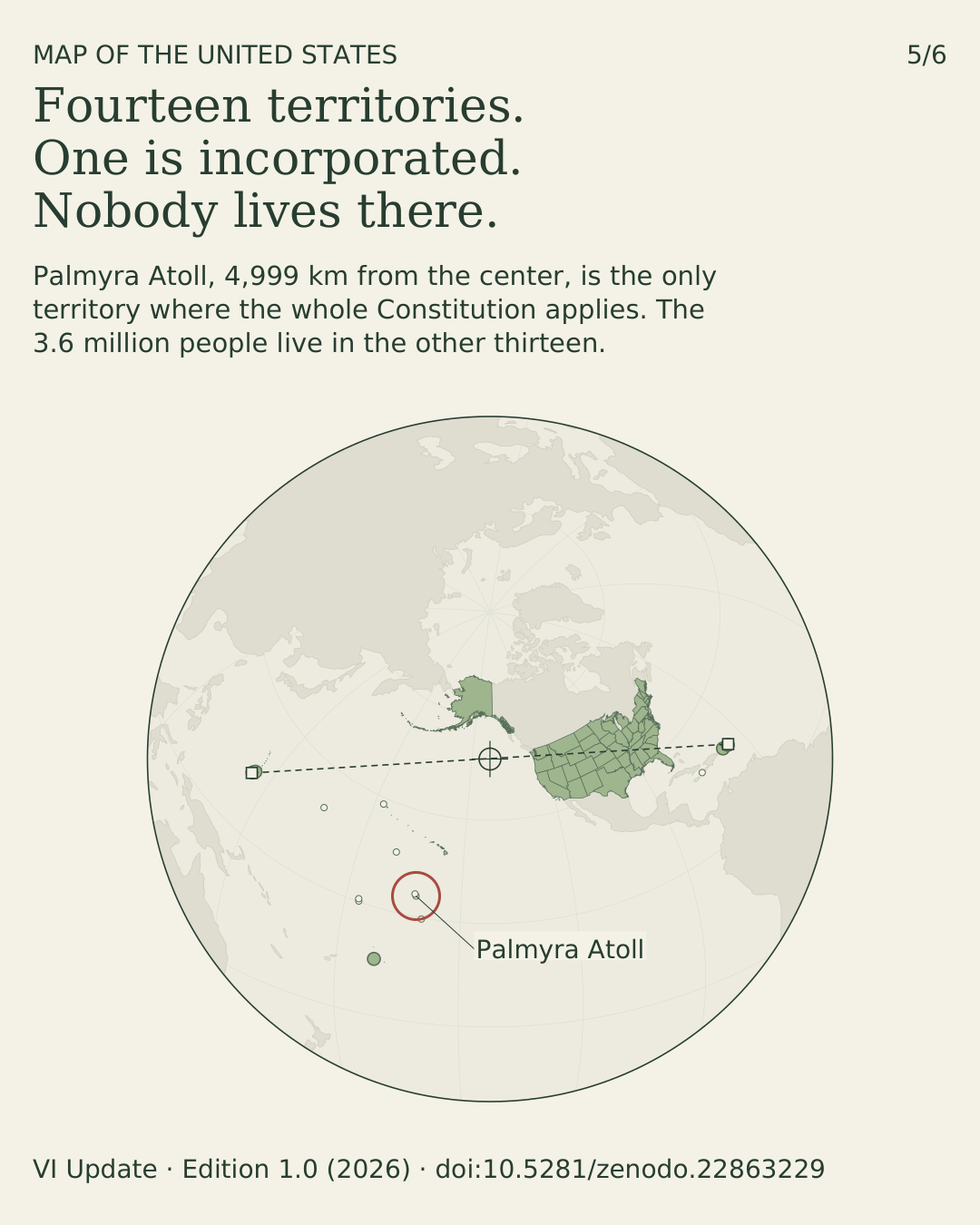
- territories is incorporated — Palmyra Atoll — and nobody lives there
Why this map
Puerto Rico, the U.S. Virgin Islands, Guam, the Northern Mariana Islands and American Samoa each get the page at their own scale. The fifty states get the small boxes at the bottom.
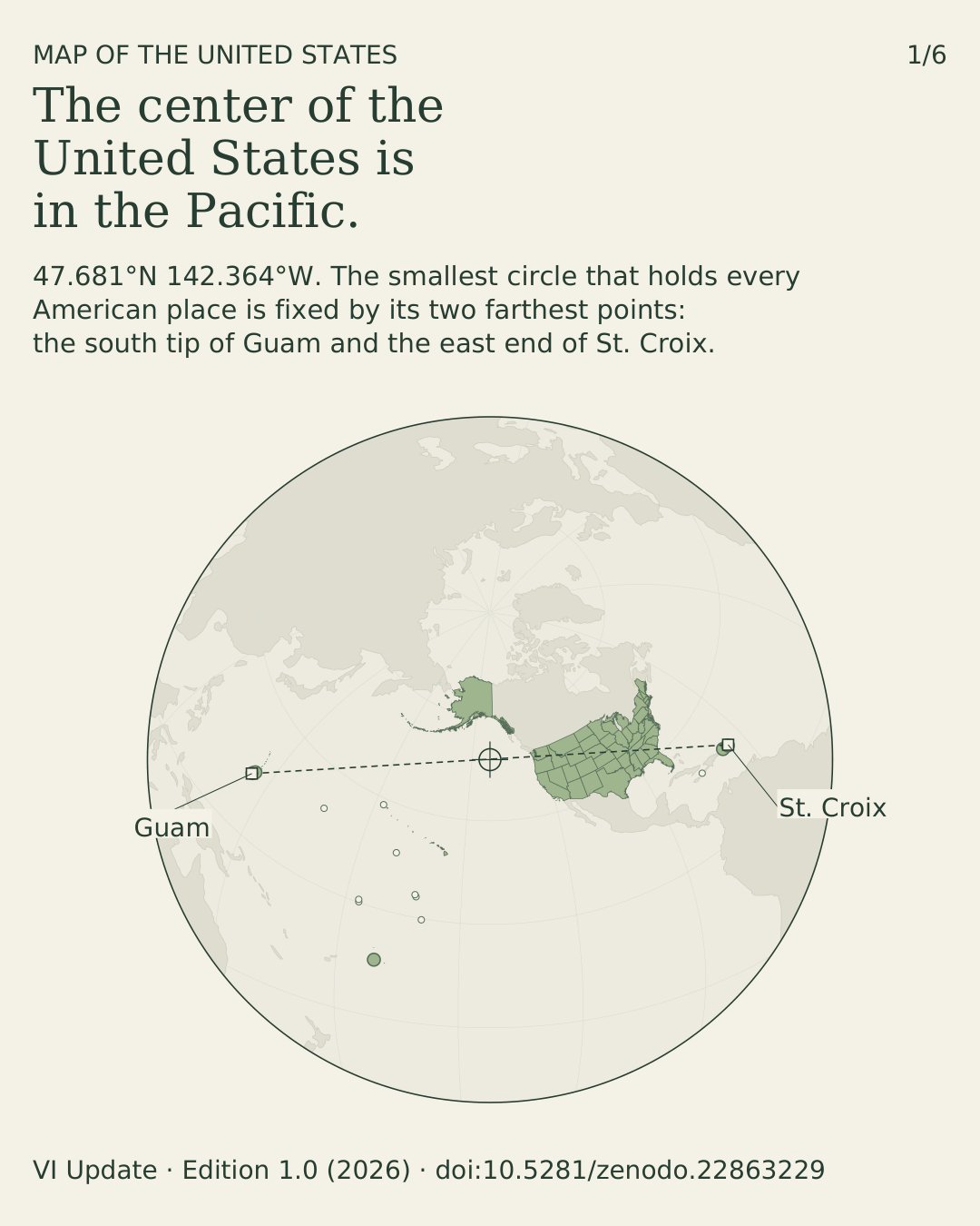
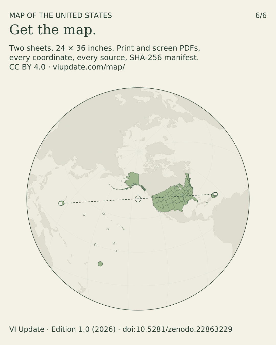
The second sheet answers the obvious objection. Take every boundary point the Census Bureau publishes for the fifty states, the District of Columbia and the five inhabited territories — 285,737 of them — and find the smallest circle on the globe that holds them all. Its center is in the North Pacific, at 47.681°N 142.364°W, and it is fixed by exactly two points: the south tip of Guam and the east end of St. Croix.

Downloads
Print: 24 × 36 inch trim, DeviceCMYK, 0.125 inch bleed, crop marks, embedded fonts, all artwork vector. The MediaBox is 24.75 × 36.75 inches to carry the marks; print at 100% and trim to the TrimBox. Screen: RGB with vector text, same drawing.
Coordinates, sources and social images
- Coordinate and scale checklist · JSON — every named point, projection, representative fraction and scale bar
- SHA-256 source manifest · JSON
- 2024–2025 boundary comparison · JSON
- Source files, build code and typefaces · ZIP, 19 MB
- Six cards in feed and story formats, with alt text · ZIP
- Five transparent 4000 px territory panels · ZIP
- Card alt text · TXT
- Deposit guide · TXT · Changelog · TXT
U.S. insular areas
Fourteen territories. Every cell is cited beneath the table; the same table is printed on Sheet 2.
| Area | Status | Organization | Population 2020 | Citizenship at birth | Voice in Congress | Electors | SSI | km from center |
|---|---|---|---|---|---|---|---|---|
| American Samoa | Unincorporated | Unorganized | 49,710 | U.S. nationals, not citizens | Delegate, 2-yr, no floor vote | None | No | 7,418 |
| Guam | Unincorporated | Organized | 153,836 | Citizens by statute (1950) | Delegate, 2-yr, no floor vote | None | No | 7,633 |
| Northern Mariana Islands | Unincorporated | Organized | 47,329 | Citizens by Covenant (1986) | Delegate, 2-yr, no floor vote | None | Yes | 7,420 |
| Puerto Rico | Unincorporated | Organized | 3,285,874 | Citizens by statute (1917) | Resident Commissioner, 4-yr, no floor vote | None | No | 7,493 |
| U.S. Virgin Islands | Unincorporated | Organized | 87,146 | Citizens by statute (1927) | Delegate, 2-yr, no floor vote | None | No | 7,590 |
| Baker Island | Unincorporated | Unorganized | Uninhabited † | — | — | — | — | 6,208 |
| Howland Island | Unincorporated | Unorganized | Uninhabited † | — | — | — | — | 6,155 |
| Jarvis Island | Unincorporated | Unorganized | Uninhabited † | — | — | — | — | 5,592 |
| Johnston Atoll | Unincorporated | Unorganized | Uninhabited † | — | — | — | — | 4,237 |
| Kingman Reef | Unincorporated | Unorganized | Uninhabited † | — | — | — | — | 4,956 |
| Midway Atoll | Unincorporated | Unorganized | Uninhabited † | — | — | — | — | 3,708 |
| Navassa Island | Unincorporated | Unorganized | Uninhabited † | — | — | — | — | 6,829 |
| Palmyra Atoll * | Incorporated | Unorganized | Uninhabited † | — | — | — | — | 4,999 |
| Wake Atoll | Unincorporated | Unorganized | Uninhabited † | — | — | — | — | 5,552 |
* Palmyra Atoll is the only incorporated U.S. territory. † No permanent civilian population; temporary military, research or refuge staff may be present. Distance: WGS 84 geodesic from the projection center (47.681°N, 142.364°W) to the capital, or to the island where uninhabited.
Scope. The fourteen U.S. territories. Excluded: the three freely associated states, which are sovereign, and the Guano Islands Act claims to Bajo Nuevo and Serranilla banks, administered by Colombia. Navassa Island (claimed by Haiti) and Wake Atoll (claimed by the Marshall Islands) are administered by the United States and are listed.
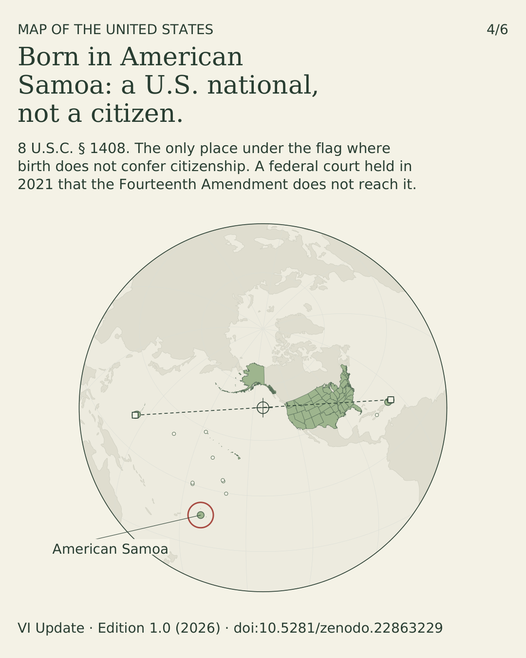
Citizenship. 8 U.S.C. § 1402 (Puerto Rico; at birth since 13 January 1941), § 1406 (Virgin Islands, Act of 25 February 1927), § 1407 (Guam, Organic Act of 1950), § 1408 with § 1101(a)(29) (American Samoa and Swains Island are “outlying possessions”: nationals, not citizens); CNMI Covenant § 301, effective 4 November 1986. The Fourteenth Amendment’s Citizenship Clause was held not to reach American Samoa in Fitisemanu v. United States, 1 F.4th 862 (10th Cir. 2021), cert. denied (2022).
Voice in Congress. One Resident Commissioner (Puerto Rico, four-year term, 48 U.S.C. § 891) and four Delegates (two-year terms, §§ 1711–1712, 1731–1732, 1751; Covenant § 901). None may vote on the House floor. Electors. Presidential electors are appointed by the States (U.S. Const. art. II, § 1, cl. 2) and by the District of Columbia (amend. XXIII); no territory appoints any. Residents vote only in party primaries.
Constitution. In unincorporated territory only “fundamental” constitutional rights apply of their own force — Downes v. Bidwell, 182 U.S. 244 (1901); the Sixth Amendment jury right does not — Balzac v. Porto Rico, 258 U.S. 298 (1922). SSI. Supplemental Security Income is payable in “the 50 States and the District of Columbia”, 42 U.S.C. § 1382c(e), and in the CNMI by Covenant § 502(a)(1); the exclusion of Puerto Rico was upheld in United States v. Vaello Madero, 596 U.S. 159 (2022). Federal income tax. Income from local sources is excluded for bona fide residents of Puerto Rico and American Samoa (26 U.S.C. §§ 933, 931); the Virgin Islands, Guam and the CNMI collect a “mirror” of the Internal Revenue Code for their own treasuries (48 U.S.C. §§ 1397, 1421i; Covenant § 601).
Authorities. 48 U.S.C. §§ 731b–731e, 734 (Puerto Rico); § 1421 et seq. (Guam); § 1541 et seq. (Virgin Islands); § 1801 note (CNMI Covenant); §§ 1661–1662 (American Samoa). Organic acts: Foraker Act (1900), Jones–Shafroth Act (1917), Pub. L. 81-600 (1950); Guam Organic Act (1950); Revised Organic Act of the Virgin Islands (1954); CNMI Covenant, Pub. L. 94-241 (1976). Palmyra: Hawaii Organic Act (1900); Hawaii Admission Act, Pub. L. 86-3, § 2; 48 U.S.C. § 644a; Executive Order 10967. Classification: U.S. Department of the Interior, Office of Insular Affairs.
Scales at published size
Representative fractions are computed from the rendered geometry at the 24 × 36 inch trim size. Bar lengths are given in pixels at 300 dpi. The checklist preserves full precision; the formula is RF denominator = 72 ÷ (0.0254 × projected points per metre).
| Sheet | Panel | Representative fraction | Scale bars · 300 dpi |
|---|---|---|---|
| 1 | Puerto Rico | 1:1,007,940 | 50 km: 585.90 px; 25 mi: 471.46 px |
| 1 | Virgin Islands | 1:554,170 | 10 km: 213.13 px; 5 mi: 171.50 px |
| 1 | Marianas chain | 1:5,395,528 | 200 km: 437.81 px; 100 mi: 352.29 px |
| 1 | Southern Marianas | 1:1,074,914 | 50 km: 549.39 px; 25 mi: 442.08 px |
| 1 | Guam | 1:425,098 | 10 km: 277.84 px; 5 mi: 223.57 px |
| 1 | Tutuila / Aunuʻu | 1:255,302 | 10 km: 462.63 px; 5 mi: 372.26 px |
| 1 | Manuʻa | 1:300,353 | 10 km: 393.24 px; 5 mi: 316.43 px |
| 1 | Swains | 1:93,410 | 1 km: 126.44 px; 0.5 mi: 101.74 px |
| 1 | Rose | 1:121,213 | 1 km: 97.44 px; 0.5 mi: 78.41 px |
| 1 | Samoa locator | 1:11,567,343 | 100 km: 102.11 px; 50 mi: 82.16 px |
| 1 | Lower 48 | 1:178,890,443 | 1000 km: 66.02 px; 500 mi: 53.13 px |
| 1 | Alaska | 1:121,056,789 | 1000 km: 97.57 px; 500 mi: 78.51 px |
| 1 | Hawaiʻi | 1:64,713,601 | 500 km: 91.26 px; 250 mi: 73.43 px |
| 2 | Polar globe | 1:42,713,839 | 2000 km: 553.03 px; 1000 mi: 445.01 px |
Mercator scales are true along each panel’s stated latitude of true scale. Albers scale varies with position and direction. The globe is azimuthal equidistant: distances are true only along lines through its center, which is the midpoint of the Guam–St. Croix chord. Horizontal datum NAD 83 / WGS 84.
Use this map
The design, layout and compilation are released under CC BY 4.0. Print it, hang it, teach with it, put it on your site. The only condition is credit.
Credit line
“The United States of America — Insular Areas and States,” Edition 1.0 (2026), compiled by Brian C. Louden, VI Update. CC BY 4.0. https://viupdate.com/map/ · doi:10.5281/zenodo.22863229
Embed
A linked preview of Sheet 2 that always points back here. Swap Sheet-2.png for Sheet-1.png for the territories sheet.
<a href="https://viupdate.com/map/"><img src="https://viupdate.com/map/Sheet-2.png" width="1383" height="2074" alt="The United States of America — Insular Areas and States, Sheet 2: a globe centered on the North Pacific showing every state and territory" style="max-width:100%;height:auto"></a>
<p>Map by Brian C. Louden, <a href="https://viupdate.com/map/">VI Update</a>, CC BY 4.0.</p>
The cards
Six cards, each the whole map with one fact. Feed (1080 × 1350) and story (1080 × 1920) formats with alt text are in the social set.
Cite it
The same files are deposited permanently on Zenodo. Cite the version DOI 10.5281/zenodo.22863229 for this edition, or the concept DOI 10.5281/zenodo.22863228, which always resolves to the latest edition. This page is the permanent address either way.
Sources and licenses
- Boundaries
- U.S. Census Bureau, 2025 Cartographic Boundary Files, 1:500,000 (GENZ2025 series, cb_2025); boundaries as of January 1, 2025. Original Census archive. Its SHA-256 is in the manifest; the copy in the source set was re-downloaded and matched on 23 September 2026.
- Population
- 2020 Census (Puerto Rico); 2020 Island Areas Censuses (American Samoa, Guam, Northern Mariana Islands, U.S. Virgin Islands). Total 3,623,895. Population counts and boundary releases are separate products; the next decennial census is 2030.
- The center
- Smallest spherical cap enclosing all 285,737 boundary vertices of the fifty states, D.C. and the five inhabited territories in the 2025 file, computed by
compute_center.pyin the source set. The cap is fixed by two vertices — Guam 13.235°N 144.645°E and St. Croix 17.752°N 64.568°W — and the center is their midpoint. Distances on the sheets are WGS 84 geodesics. - Town coordinates
- GeoNames (CC BY 4.0).
- Atoll lagoon and reef detail
- © OpenStreetMap contributors (ODbL).
swains.osmandrose.osmin the source set are OSM extracts. - Globe context and minor-island geometry
- Natural Earth (public domain).
- Typefaces
- DejaVu Serif, Serif Italic, Sans and Sans Bold, embedded in the PDFs; embedding and commercial distribution permitted (fsType 0). The full license is in the source set.
- Projections
- Local Mercator (regional panels); Albers equal-area (Lower 48, Alaska); Mercator (Hawaiʻi); azimuthal equidistant (globe). Datum NAD 83 / WGS 84.
Changelog
Edition 1.0 · 23 September 2026
Named the two boundary points that fix the globe’s center and drew the great circle between them, with its length; labelled the center’s coordinates. Extended the insular-area table with citizenship at birth, voice in Congress, presidential electors, SSI and distance from the center, each cell cited. Town labels now always sit on water. Sheets rebuilt from source with compressed PDFs and full document metadata; the center is now derived from the 2025 archive by compute_center.py. Geometry, projections and panel extents unchanged.
22 September 2026
Permanent address set to viupdate.com/map/ in both QR codes and printed links.
20 September 2026
Re-plotted Census geography from the 2025 archive. Comparison of all five inhabited territories found no material change: the largest measured Hausdorff separation is approximately 0.09 m in the Virgin Islands. Corrected Asuncion to 19.6725°N, 145.4058°E; standardized Midway Atoll.
Full changelog · Corrections: tips@viupdate.com. Errata will be recorded on this page.